Garmin ECHOMAP94SV Chirp 9"
Garmin echoMAP 94sv 9" CHIRP Fishfinder Chart Plotter Preloaded BlueChart® g2 charts for the coastal U.S. WITH Transom Mount
Model: 010-01805-01
UPC: 753759176129
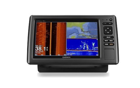
9-inch color display with keypad control
Preloaded BlueChart® g2 charts for the coastal U.S.
Preloaded Quickdraw Contours custom HD map creation software
Panoptix™ all-seeing sonar support (transducer not included)
Includes transducer with high wide CHIRP (250 W) and CHIRP ClearVü/SideVü (455/800 kHz, 500 W)
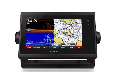
It’s time you started fishing with the power of CHIRP sonar. The easy-to-install, easy-to-use 9-inch echoMAP CHIRP 94sv chartplotter includes transducer for high wide CHIRP sonar and Garmin CHIRP SideVü™ and Garmin CHIRP ClearVü™ for clear scanning sonar images. It supports Panoptix sonar and includes preloaded Quickdraw Contours software to instantly create your own HD maps with 1-foot contours as you fish. Internal 5 Hz GPS updates position and heading 5 times per second. It provides NMEA 2000® support for engine data, sensors, FUSION-LINK™ audio system, autopilots and more. Cords plug directly into the mount, allowing you to quickly install and remove your device from power and mount. Transom and trolling motor mounts included.
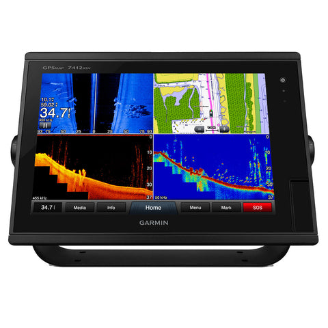
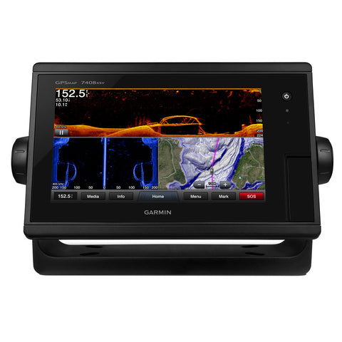
The built-in sonar capabilities of echoMAP 94sv include CHIRP sonar, the most sophisticated sonar technology available for the fishing and boating public. CHIRP sonar provides amazingly clear target separation and definition because it puts even more energy onto the target than traditional sonar. It also includes sonar-recording capability that coordinates the timing of the sonar return with your boat's position and saves digital information for playback on a computer using HomePort™ planning software. Use the user data sharing cable to share waypoints and routes between multiple devices.
Garmin CHIRP ClearVü and CHIRP SideVü scanning sonars give you nearly photographic, wide images of what’s below and to the sides of your boat. You clearly see structure, submerged objects and fish. Also supports Minn Kota® and MotorGuide® trolling motors with integrated transducers.
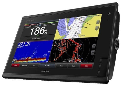
echoMAP 94sv is preloaded with BlueChart g2 HD maps covering the coastal U.S. (East Coast, West Coast, Gulf of Mexico, U.S. and Canadian sides of the Great Lakes). It also includes all U.S. charts for the entire coastline as well as everything available on NOAA charts. In addition to the basic charts, tidal stations, currents, depth contours, IALA symbols and included fishing charts, BlueChart g2 HD offers smooth transitioning between zoom levels and more seamless continuity across chart boundaries. Customize your screens with Shallow Water Shading, which allows you to contour shade for all depth contours shallower than what you determine is your safe depth. Fishing charts emphasize bathymetric contours with less visual clutter on the display. And there’s also a choice of standard 2-D direct overhead or 3-D "over-the-bow" map views for easier chart reading and orientation.
Instantly create personalized HD fishing maps onscreen with 1-foot contours. Tailor them to fit your needs. These are your maps — you own them. Keep the data to yourself, or share it with the Quickdraw Community on Garmin Connect™.
Fast, responsive 5 Hz GPS and GLONASS refreshes your position and heading 5 times each second to make your movement on the screen more fluid. Now it’s quick and easy to drop up to 5,000 accurate waypoints and find your way back to your secret fishing hot spots.
With LiveVü Forward your boat can be moving or stationary. Wherever your trolling motor is pointed, you will see live images of what is happening under the water. Watch your lure as it sinks, and see its depth and movement as you retrieve it. See it move in relationship to structures in the water. See fish swimming, reacting to your bait; if they attack, you’ll see and feel the hit. Once on the hook, watch the fight on your screen as it happens. With Panoptix LiveVü Forward, you can see it all come to life up to 100 feet away.
When you’re off the water, it’s easy to keep your echoMAP CHIRP safe and secure. You don’t have to mess with plugging and unplugging wires from the unit because the cords plug directly into the mount. This allows you to quickly install and remove your echoMAP CHIRP from power and the mount.
A single microSD™ card slot provides expandable memory for accessory map purchases, such as LakeVü HD Ultra with Max Def Lakes or BlueChart® g2 Vision® HD, which adds Garmin patented Auto Guidance1 and other great features.
If you have waypoints, tracks or frequently used routes stored on another manufacturer’s GPS product - or on a Garmin handheld device - now it’s easier than ever to transfer those items to your new Garmin chartplotter, via industry-standard GPX software formatting.
Supported SailAssist features include laylines, enhanced wind rose, heading and course-over-ground lines and true wind data fields. Gauge displays are designed to provide important, need-to-know information at a glance, including true and apparent wind angle, set and drift, true or apparent wind speed, horizontal graphs and a data bar with customizable data fields. To help you gain a wind-maximizing competitive edge, your chartplotter features a pre-race guidance page that shows your virtual starting line along with data fields showing laylines, time to burn before the start and a race timer.
Auto Guidance is for planning purposes only and does not replace safe navigation operations.
Specifications
Display size 4.4"x7.8"; 9" diagonal
Display resolution 480 x 800 pixels
Display type WVGA display
Water rating IPX7
Antenna Internal or external over NMEA 2000
NMEA0183 Compatible Yes
Garmin Marine Network ports 1 Panoptix™ port
Maps & Memory
Preloaded maps BlueChart® g2 (coastal maps)
Accepts data cards 1 microSD™ card
Waypoints 5,000
Routes 100
Track log 50,000 points; 50 saved tracks
Chartplotter Features
Garmin Sonar compatible Yes
Supports AIS (tracks target ships position) Yes
Supports DSC (displays position data from DSC-capable VHF radio) Yes
Tide tables Yes
BlueChart® Mobile (planning) compatible No
Sonar Features and Specifications
Dual-frequency (50/200 kHz) sonar capable Yes
Dual-beam (77/200 kHz) sonar capable Yes
Transmit power 500 W (RMS) / 4,000 W (peak to peak)
CHIRP sonar technology Yes, built-in
ClearVü™ Yes, built-in
SideVü™ Yes, built-in
Maximum depth 2,300 ft @ 77 kHz, freshwater
1,100 ft @ 77 kHz, saltwater
(depth capacity is dependent on water bottom type and other water conditions)
Bottom lock (shows return from the bottom up) Yes
Water temperature log and graph Yes
Sonar recording Yes
Sonar history rewind Yes
Connections
NMEA 0183 input ports 1
NMEA 0183 output ports 1
Video input ports None
Video output ports None
Wireless connectivity No
NMEA 2000® compatible Yes
Dimensions 11.3"x6.4"x2" (28.8cmx16.3cm x5.1cm)
What's in the Box:
echoMAP CHIRP 94sv with U.S. BlueChart® g2
Power/data cable
Tilt Mount
Quick-release cradle
Protective cover
Flush Mount Kit
Hardware
Documentation
Transducer (12-pin)
Transom mount
Additional Information
Model: 010-01805-01
UPC: 753759176129
9-inch color display with keypad control
Preloaded BlueChart® g2 charts for the coastal U.S.
Preloaded Quickdraw Contours custom HD map creation software
Panoptix™ all-seeing sonar support (transducer not included)
Includes transducer with high wide CHIRP (250 W) and CHIRP ClearVü/SideVü (455/800 kHz, 500 W)
It’s time you started fishing with the power of CHIRP sonar. The easy-to-install, easy-to-use 9-inch echoMAP CHIRP 94sv chartplotter includes transducer for high wide CHIRP sonar and Garmin CHIRP SideVü™ and Garmin CHIRP ClearVü™ for clear scanning sonar images. It supports Panoptix sonar and includes preloaded Quickdraw Contours software to instantly create your own HD maps with 1-foot contours as you fish. Internal 5 Hz GPS updates position and heading 5 times per second. It provides NMEA 2000® support for engine data, sensors, FUSION-LINK™ audio system, autopilots and more. Cords plug directly into the mount, allowing you to quickly install and remove your device from power and mount. Transom and trolling motor mounts included.
The built-in sonar capabilities of echoMAP 94sv include CHIRP sonar, the most sophisticated sonar technology available for the fishing and boating public. CHIRP sonar provides amazingly clear target separation and definition because it puts even more energy onto the target than traditional sonar. It also includes sonar-recording capability that coordinates the timing of the sonar return with your boat's position and saves digital information for playback on a computer using HomePort™ planning software. Use the user data sharing cable to share waypoints and routes between multiple devices.
Garmin CHIRP ClearVü and CHIRP SideVü scanning sonars give you nearly photographic, wide images of what’s below and to the sides of your boat. You clearly see structure, submerged objects and fish. Also supports Minn Kota® and MotorGuide® trolling motors with integrated transducers.
echoMAP 94sv is preloaded with BlueChart g2 HD maps covering the coastal U.S. (East Coast, West Coast, Gulf of Mexico, U.S. and Canadian sides of the Great Lakes). It also includes all U.S. charts for the entire coastline as well as everything available on NOAA charts. In addition to the basic charts, tidal stations, currents, depth contours, IALA symbols and included fishing charts, BlueChart g2 HD offers smooth transitioning between zoom levels and more seamless continuity across chart boundaries. Customize your screens with Shallow Water Shading, which allows you to contour shade for all depth contours shallower than what you determine is your safe depth. Fishing charts emphasize bathymetric contours with less visual clutter on the display. And there’s also a choice of standard 2-D direct overhead or 3-D "over-the-bow" map views for easier chart reading and orientation.
Instantly create personalized HD fishing maps onscreen with 1-foot contours. Tailor them to fit your needs. These are your maps — you own them. Keep the data to yourself, or share it with the Quickdraw Community on Garmin Connect™.
Fast, responsive 5 Hz GPS and GLONASS refreshes your position and heading 5 times each second to make your movement on the screen more fluid. Now it’s quick and easy to drop up to 5,000 accurate waypoints and find your way back to your secret fishing hot spots.
With LiveVü Forward your boat can be moving or stationary. Wherever your trolling motor is pointed, you will see live images of what is happening under the water. Watch your lure as it sinks, and see its depth and movement as you retrieve it. See it move in relationship to structures in the water. See fish swimming, reacting to your bait; if they attack, you’ll see and feel the hit. Once on the hook, watch the fight on your screen as it happens. With Panoptix LiveVü Forward, you can see it all come to life up to 100 feet away.
When you’re off the water, it’s easy to keep your echoMAP CHIRP safe and secure. You don’t have to mess with plugging and unplugging wires from the unit because the cords plug directly into the mount. This allows you to quickly install and remove your echoMAP CHIRP from power and the mount.
A single microSD™ card slot provides expandable memory for accessory map purchases, such as LakeVü HD Ultra with Max Def Lakes or BlueChart® g2 Vision® HD, which adds Garmin patented Auto Guidance1 and other great features.
If you have waypoints, tracks or frequently used routes stored on another manufacturer’s GPS product - or on a Garmin handheld device - now it’s easier than ever to transfer those items to your new Garmin chartplotter, via industry-standard GPX software formatting.
Supported SailAssist features include laylines, enhanced wind rose, heading and course-over-ground lines and true wind data fields. Gauge displays are designed to provide important, need-to-know information at a glance, including true and apparent wind angle, set and drift, true or apparent wind speed, horizontal graphs and a data bar with customizable data fields. To help you gain a wind-maximizing competitive edge, your chartplotter features a pre-race guidance page that shows your virtual starting line along with data fields showing laylines, time to burn before the start and a race timer.
Auto Guidance is for planning purposes only and does not replace safe navigation operations.
Specifications
Display size 4.4"x7.8"; 9" diagonal
Display resolution 480 x 800 pixels
Display type WVGA display
Water rating IPX7
Antenna Internal or external over NMEA 2000
NMEA0183 Compatible Yes
Garmin Marine Network ports 1 Panoptix™ port
Maps & Memory
Preloaded maps BlueChart® g2 (coastal maps)
Accepts data cards 1 microSD™ card
Waypoints 5,000
Routes 100
Track log 50,000 points; 50 saved tracks
Chartplotter Features
Garmin Sonar compatible Yes
Supports AIS (tracks target ships position) Yes
Supports DSC (displays position data from DSC-capable VHF radio) Yes
Tide tables Yes
BlueChart® Mobile (planning) compatible No
Sonar Features and Specifications
Dual-frequency (50/200 kHz) sonar capable Yes
Dual-beam (77/200 kHz) sonar capable Yes
Transmit power 500 W (RMS) / 4,000 W (peak to peak)
CHIRP sonar technology Yes, built-in
ClearVü™ Yes, built-in
SideVü™ Yes, built-in
Maximum depth 2,300 ft @ 77 kHz, freshwater
1,100 ft @ 77 kHz, saltwater
(depth capacity is dependent on water bottom type and other water conditions)
Bottom lock (shows return from the bottom up) Yes
Water temperature log and graph Yes
Sonar recording Yes
Sonar history rewind Yes
Connections
NMEA 0183 input ports 1
NMEA 0183 output ports 1
Video input ports None
Video output ports None
Wireless connectivity No
NMEA 2000® compatible Yes
Dimensions 11.3"x6.4"x2" (28.8cmx16.3cm x5.1cm)
What's in the Box:
echoMAP CHIRP 94sv with U.S. BlueChart® g2
Power/data cable
Tilt Mount
Quick-release cradle
Protective cover
Flush Mount Kit
Hardware
Documentation
Transducer (12-pin)
Transom mount
Additional Information
We Also Recommend