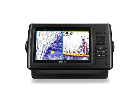
GARMIN ECHOMAP74DV CHIRP 7" COMBO BLUECHART G2 GT23-TM
Garmin echoMAP 74dv 7" CHIRP Fishfinder Chart Plotter BlueChart® g2 charts for the coastal U.S with GT23-TM
Model: 010-01572-01
UPC: 753759147686
•7-inch color display with keypad control
•Includes BlueChart® g2 charts for the coastal U.S.
•Includes Quickdraw Contours custom HD map creation software
•Preloaded Quickdraw Contours custom HD map creation software
•Panoptix™ all-seeing sonar support (transducer not included)
It’s time you started fishing with the power of CHIRP sonar. The easy-to-install, easy-to-use 7-inch-inch echoMAP CHIRP 74dv chartplotter/sonar combo includes transducer for high wide CHIRP sonar and Garmin CHIRP DownVü, the clearest scanning sonar on the water. It supports Panoptix and includes preloaded Quickdraw Contours software to instantly create your own HD maps with 1-foot contours as you fish. Internal 5 Hz GPS updates position and heading 5 times per second. It provides NMEA 2000® support for engine data, sensors, autopilots and more. Cords plug directly into the mount, allowing you to quickly install and remove your device from power and mount. Transom and trolling motor mounts included.
The Garmin CHIRP Difference
The built-in sonar capabilities of echoMAP 74dv include CHIRP sonar, the most sophisticated sonar technology available for the fishing and boating public. CHIRP sonar provides amazingly clear target separation and definition because it puts even more energy onto the target than traditional sonar. It also includes sonar-recording capability that coordinates the timing of the sonar return with your boat's position and saves digital information for playback on a computer using HomePort™ planning software. Use the user data sharing cable to share waypoints and routes between multiple devices.
Clearest Scanning Sonar on the Water
Garmin DownVü scanning sonar gives you a nearly photographic image down to 750 feet below your boat. You clearly see structure, submerged objects and fish. Traditional Garmin HD-ID™ sonar and DownVü scanning sonar are combined into 1 transducer. Also provides HD-ID support for Minn Kota® and MotorGuide® trolling motors with integrated transducers.
Create Your Own HD Maps
Quickdraw Contours is a free, easy-to-use software feature already installed on your echoMAP CHIRP 42dv. It instantly creates your own personalized HD fishing maps on screen with 1-foot contours. Tailor the maps as needed; you own them. Keep the data for yourself, or share it with Garmin or your friends. No special surveying expertise is required. You just fish while Quickdraw Contours creates maps. There’s no waiting around or sending your files away like other mapping software requires — your results appear instantly. Use with any Garmin Panoptix™ transducer, any HD-ID sonar, any CHIRP-enabled, Garmin DownVü transducer or NMEA 2000®-compatible depth transducer. Have more than 1 sonar device installed onboard? Quickdraw Contours automatically selects the most capable sonar device to provide the very best results for you.
Heading and Position Refreshed 5 Times per Second
Fast, responsive 5 Hz GPS/GLONASS refreshes your position and heading 5 times each second to make your movement on the screen more fluid. Now it’s quick and easy to drop up to 5,000 accurate waypoints and find your way back to your secret fishing hot spots.
Take Your echoMAP with You
When you’re off the water, it’s easy to keep your echoMAP safe and secure. You don’t have to mess with plugging and unplugging wires from the unit because the cords plug directly into the mount. This allows you to quickly install and remove your echoMAP from power and the mount.
Upgrade with the Best Maps on the Water
A single microSD™ card slot provides expandable memory for accessory map purchases such as BlueChart® g2, BlueChart® g2 Vision®, LakeVü HD or LakeVü HD Ultra. LakeVü HD Ultra and BlueChart g2 Vision provide exclusive Garmin Auto Guidance, a technology that directs you to your hot spots by instantly creating an on-screen path based on your boat’s specifications that you can follow to avoid shallow water and other charted obstructions.
Enhanced Auto Guidance
Just enter the location where you want to go and patented Garmin Auto Guidance technology instantly searches through relevant charts to create a safe, virtual pathway on the display that helps you avoid low bridges, shallow water and other charted obstructions en route.
With enhanced Version 2.0, you have access to more features and capabilities. You’re able to adjust the calculated Auto Guidance pathway by inserting ?via? points at interim stops or landmarks along your desired route. You can easily review hazard points along your calculated path. And you can even engage your compatible Garmin autopilot to follow the Auto Guidance route, automatically. Other 2.0 enhancements give you the ability to calculate arrival times at any point on your route (great for timing arrivals to correspond with bridge openings and other time-critical events). Better still, you can now save your plotted Auto Guidance paths for future navigation by backing them up on an SD™ card with your BlueChart g2 Vision or LakeVü HD Ultra cartography .
GPX Waypoints Transfer
If you have waypoints, tracks or frequently used routes stored on another manufacturer’s GPS product - or on a Garmin handheld device - now it’s easier than ever to transfer those items to your new Garmin chartplotter, via industry-standard GPX software formatting. GPX is an open standard format for GPS data exchange across platforms and applications. With this easy-to-use interface technology, Garmin has taken ?no waypoint left behind? to a whole new level of trade-up convenience.
Preloaded BlueChart g2 Maps
echoMAP 74dv is preloaded with BlueChart g2 maps covering the coastal U.S. (East Coast, West Coast, Gulf of Mexico, U.S. and Canadian sides of the Great Lakes). It also includes all U.S. charts for the entire coastline as well as everything available on NOAA charts. In addition to the basic charts, tidal stations, currents, depth contours, IALA symbols and included fishing charts, BlueChart g2 offers smooth transitioning between zoom levels and more seamless continuity across chart boundaries. Customize your screens with Shallow Water Shading, which allows you to contour shade for all depth contours shallower than what you determine is your safe depth. Fishing charts emphasize bathymetric contours with less visual clutter on the display. And there’s also a choice of standard 2-D direct overhead or 3-D ?over-the-bow? map views for easier chart reading and orientation.
Add Panoptix LiveVü Forward Sonar
With LiveVü Forward your boat can be moving or stationary. Wherever your trolling motor is pointed, you will see live images of what is happening under the water. Watch your lure as it sinks, and see its depth and movement as you retrieve it. See it move in relationship to structures in the water. See fish swimming, reacting to your bait; if they attack, you’ll see and feel the hit. Once on the hook, watch the fight on your screen as it happens. With Panoptix LiveVü Forward, you can see it all come to life up to 100 feet away.
Specifications
Display size 6.0"x3.6"; 7.0" diagonal
Display resolution 480 x 800 pixels
Display type WVGA display
Water rating IPX7
Antenna Internal only
NMEA0183 Compatible Yes
Garmin Marine Network ports 1 Panoptix™ port
Maps & Memory
Preloaded maps BlueChart® g2 (coastal maps)
Accepts data cards 1 microSD™ card
Waypoints 5,000
Routes 100
Track log 50,000 points; 50 saved tracks
Chartplotter Features
Garmin Sonar compatible Yes
Supports AIS (tracks target ships position) Yes
Supports DSC (displays position data from DSC-capable VHF radio) Yes
Tide tables Yes
BlueChart® Mobile (planning) compatible No
Sonar Features and Specifications
Dual-frequency (50/200 kHz) sonar capable Yes
Dual-beam (77/200 kHz) sonar capable Yes
Transmit power 500 W (RMS) / 4,000 W (peak to peak)
CHIRP sonar technology Yes, built-in
DownVü™ Yes, built-in
SideVü™ No
Maximum depth 2,300 ft @ 77 kHz, freshwater
1,100 ft @ 77 kHz, saltwater
(depth capacity is dependent on water bottom type and other water conditions)
Bottom lock (shows return from the bottom up) Yes
Water temperature log and graph Yes
Sonar recording Yes
Sonar history rewind Yes
Connections
NMEA 0183 input ports 1
NMEA 0183 output ports 1
Video input ports None
Video output ports None
Wireless connectivity No
Dimensions 9.8"x5.5"x2" (25cmx13.9cmx5.1cm)
What's in the Box:•echoMAP CHIRP 74dv with U.S. BlueChart® g2
•Power/data cable
•Tilt Mount
•Quick-release cradle
•Protective cover
•Flush Mount Kit
•Hardware
•Documentation
•GT23M-TM transducer (8-pin)
•Transom mount
We Also Recommend